- Article
(9035 KB) - Metadata XML
- October 20, 2026
- |
- Home
- |
- Sitemap
- |
- The ISPRS Foundation
- |
- 𝕏
ISPRS Annals of the Photogrammetry, Remote Sensing and Spatial Information Sciences





Articles | Volume XI-3-2026
https://doi.org/10.5194/isprs-annals-XI-3-2026-779-2026
© Author(s) 2026. This work is distributed under
the Creative Commons Attribution 4.0 License.
the Creative Commons Attribution 4.0 License.
https://doi.org/10.5194/isprs-annals-XI-3-2026-779-2026
© Author(s) 2026. This work is distributed under
the Creative Commons Attribution 4.0 License.
the Creative Commons Attribution 4.0 License.

08 Jul 2026
| 08 Jul 2026
Comparing DeepLabv3+ and Depth Anything V2 on Canopy Height Model Prediction on a Continental Scale Dataset of Australia
Kevin Qiu
Fraunhofer IOSB, 76725 Ettlingen, Germany
Rewanth Ravindran
Technical University of Darmstadt, Darmstadt, Germany
Nicolas Pucino
Fenner School of Environment and Society, Australian National University, Canberra, ACT, Australia
CSIRO Environment, ACT, SA, Australia
Dimitri Bulatov
Fraunhofer IOSB, 76725 Ettlingen, Germany
Shaun Levick
CSIRO Environment, Urrbrae, SA, Australia
Martin Brand
Department of Geosciences and Natural Resource Management, University of Copenhagen, Copenhagen, Denmark
Dorota Iwaszczuk
Technical University of Darmstadt, Darmstadt, Germany
Tim R. McVicar
CSIRO Environment, ACT, SA, Australia
Related authors
Edwin Deisling, Raphael Zipperer, Benedikt Kottler, Kevin Qiu, Melanie Böge, and Dimitri Bulatov
Int. Arch. Photogramm. Remote Sens. Spatial Inf. Sci., XLIX-B3-2026, 57–64, https://doi.org/10.5194/isprs-archives-XLIX-B3-2026-57-2026, https://doi.org/10.5194/isprs-archives-XLIX-B3-2026-57-2026, 2026
Melanie Böge, Dimitri Bulatov, Edwin Deisling, Gisela Häufel, and Kevin Qiu
ISPRS Ann. Photogramm. Remote Sens. Spatial Inf. Sci., X-4-W6-2025, 17–24, https://doi.org/10.5194/isprs-annals-X-4-W6-2025-17-2025, https://doi.org/10.5194/isprs-annals-X-4-W6-2025-17-2025, 2025
Kevin Qiu, Isabella Mebus Kishi de Oliveira, Dimitri Bulatov, and Dorota Iwaszczuk
ISPRS Ann. Photogramm. Remote Sens. Spatial Inf. Sci., X-4-W6-2025, 177–184, https://doi.org/10.5194/isprs-annals-X-4-W6-2025-177-2025, https://doi.org/10.5194/isprs-annals-X-4-W6-2025-177-2025, 2025
Qipeng Mei, Kevin Qiu, Dimitri Bulatov, and Dorota Iwaszczuk
ISPRS Ann. Photogramm. Remote Sens. Spatial Inf. Sci., X-4-W5-2024, 229–236, https://doi.org/10.5194/isprs-annals-X-4-W5-2024-229-2024, https://doi.org/10.5194/isprs-annals-X-4-W5-2024-229-2024, 2024
Dimitri Bulatov, Dirk Frommholz, Benedikt Kottler, Kevin Qui, and Eva Strauss
ISPRS Ann. Photogramm. Remote Sens. Spatial Inf. Sci., X-2-2024, 17–24, https://doi.org/10.5194/isprs-annals-X-2-2024-17-2024, https://doi.org/10.5194/isprs-annals-X-2-2024-17-2024, 2024
Qipeng Mei, Dimitri Bulatov, and Dorota Iwaszczuk
Int. Arch. Photogramm. Remote Sens. Spatial Inf. Sci., L-4-W2-2026, 125–132, https://doi.org/10.5194/isprs-archives-L-4-W2-2026-125-2026, https://doi.org/10.5194/isprs-archives-L-4-W2-2026-125-2026, 2026
Andres Barrio-Martin, Carlos Calvo-Sancho, Nuria P. Plaza-Martin, Cesar Azorin-Molina, Andreas F. Prein, Tim R. McVicar, Sergio M. Vicente-Serrano, Luis Gimeno, Raquel Nieto, Zhenzhong Zeng, Ana Morata, and Deliang Chen
EGUsphere, https://doi.org/10.5194/egusphere-2026-5202, https://doi.org/10.5194/egusphere-2026-5202, 2026
This preprint is open for discussion and under review for Natural Hazards and Earth System Sciences (NHESS).
Short summary
Short summary
We identified the atmospheric conditions that distinguish ordinary thunderstorms from four severe weather hazards, highlighting numerical proxies for their modelling in the Mediterranean. Severe winds occur in warm, unstable air (summer) or with strong mid-level winds (other seasons); tornadoes are favored by instability near the ground; large hail occurs when instability and strong winds combine; and short-duration heavy precipitation is favored by high moisture and slow-moving thunderstorms.
Divar Castro-Rodas, André Pico Molineros, Rahisha Thottolil, Dimitri Bulatov, Eder M.S. de Paula, and Andrés Velastegui-Montoya
Int. Arch. Photogramm. Remote Sens. Spatial Inf. Sci., XLIX-B3-2026, 565–572, https://doi.org/10.5194/isprs-archives-XLIX-B3-2026-565-2026, https://doi.org/10.5194/isprs-archives-XLIX-B3-2026-565-2026, 2026
Eva Strauss, Dimitri Bulatov, Edwin Deisling, Arno Schmidt, Peter Solbrig, Daniel Wagner, Alexander Gatter, and Martin Kolloch
Int. Arch. Photogramm. Remote Sens. Spatial Inf. Sci., XLIX-B3-2026, 431–438, https://doi.org/10.5194/isprs-archives-XLIX-B3-2026-431-2026, https://doi.org/10.5194/isprs-archives-XLIX-B3-2026-431-2026, 2026
Benedikt Kottler, Raphael Zipperer, Eva Strauss, and Dimitri Bulatov
Int. Arch. Photogramm. Remote Sens. Spatial Inf. Sci., XLIX-B3-2026, 395–403, https://doi.org/10.5194/isprs-archives-XLIX-B3-2026-395-2026, https://doi.org/10.5194/isprs-archives-XLIX-B3-2026-395-2026, 2026
Edwin Deisling, Raphael Zipperer, Benedikt Kottler, Kevin Qiu, Melanie Böge, and Dimitri Bulatov
Int. Arch. Photogramm. Remote Sens. Spatial Inf. Sci., XLIX-B3-2026, 57–64, https://doi.org/10.5194/isprs-archives-XLIX-B3-2026-57-2026, https://doi.org/10.5194/isprs-archives-XLIX-B3-2026-57-2026, 2026
Rewanth Ravindran, Janik Steier, Samer Karam, and Dorota Iwaszczuk
Int. Arch. Photogramm. Remote Sens. Spatial Inf. Sci., XLIX-B1-2026, 599–605, https://doi.org/10.5194/isprs-archives-XLIX-B1-2026-599-2026, https://doi.org/10.5194/isprs-archives-XLIX-B1-2026-599-2026, 2026
Jiwei Hou, Vivien Volland, Samer Karam, and Dorota Iwaszczuk
ISPRS Ann. Photogramm. Remote Sens. Spatial Inf. Sci., XI-1-2026, 255–262, https://doi.org/10.5194/isprs-annals-XI-1-2026-255-2026, https://doi.org/10.5194/isprs-annals-XI-1-2026-255-2026, 2026
Janik Steier and Dorota Iwaszczuk
Int. Arch. Photogramm. Remote Sens. Spatial Inf. Sci., XLVIII-1-W6-2025, 227–233, https://doi.org/10.5194/isprs-archives-XLVIII-1-W6-2025-227-2025, https://doi.org/10.5194/isprs-archives-XLVIII-1-W6-2025-227-2025, 2025
Mona Goebel, Lukas Wolf, Frederik Packwitz, and Dorota Iwaszczuk
Int. Arch. Photogramm. Remote Sens. Spatial Inf. Sci., XLVIII-2-W11-2025, 95–102, https://doi.org/10.5194/isprs-archives-XLVIII-2-W11-2025-95-2025, https://doi.org/10.5194/isprs-archives-XLVIII-2-W11-2025-95-2025, 2025
Kevin Qiu, Isabella Mebus Kishi de Oliveira, Dimitri Bulatov, and Dorota Iwaszczuk
ISPRS Ann. Photogramm. Remote Sens. Spatial Inf. Sci., X-4-W6-2025, 177–184, https://doi.org/10.5194/isprs-annals-X-4-W6-2025-177-2025, https://doi.org/10.5194/isprs-annals-X-4-W6-2025-177-2025, 2025
Melanie Böge, Dimitri Bulatov, Edwin Deisling, Gisela Häufel, and Kevin Qiu
ISPRS Ann. Photogramm. Remote Sens. Spatial Inf. Sci., X-4-W6-2025, 17–24, https://doi.org/10.5194/isprs-annals-X-4-W6-2025-17-2025, https://doi.org/10.5194/isprs-annals-X-4-W6-2025-17-2025, 2025
Nicolas Pucino, Tim McVicar, Shaun Levick, and Albert van Dijk
Int. Arch. Photogramm. Remote Sens. Spatial Inf. Sci., XLVIII-G-2025, 1223–1227, https://doi.org/10.5194/isprs-archives-XLVIII-G-2025-1223-2025, https://doi.org/10.5194/isprs-archives-XLVIII-G-2025-1223-2025, 2025
Qais Al-Badi, Petra Helmholz, and Dimitri Bulatov
Int. Arch. Photogramm. Remote Sens. Spatial Inf. Sci., XLVIII-G-2025, 123–130, https://doi.org/10.5194/isprs-archives-XLVIII-G-2025-123-2025, https://doi.org/10.5194/isprs-archives-XLVIII-G-2025-123-2025, 2025
Rewanth Ravindran, Yannick Treitz, and Dorota Iwaszczuk
ISPRS Ann. Photogramm. Remote Sens. Spatial Inf. Sci., X-G-2025, 705–712, https://doi.org/10.5194/isprs-annals-X-G-2025-705-2025, https://doi.org/10.5194/isprs-annals-X-G-2025-705-2025, 2025
Timo Kullmann, Patrick Hübner, Tristan Wirth, Arjan Kuijper, and Dorota Iwaszczuk
Int. Arch. Photogramm. Remote Sens. Spatial Inf. Sci., XLVIII-2-W8-2024, 251–258, https://doi.org/10.5194/isprs-archives-XLVIII-2-W8-2024-251-2024, https://doi.org/10.5194/isprs-archives-XLVIII-2-W8-2024-251-2024, 2024
Aleksandar Atanasov, Benedikt Kottler, and Dimitri Bulatov
Int. Arch. Photogramm. Remote Sens. Spatial Inf. Sci., XLVIII-4-2024, 27–35, https://doi.org/10.5194/isprs-archives-XLVIII-4-2024-27-2024, https://doi.org/10.5194/isprs-archives-XLVIII-4-2024-27-2024, 2024
Dimitri Bulatov, Yousif A. Mousa, and Petra Helmholz
ISPRS Ann. Photogramm. Remote Sens. Spatial Inf. Sci., X-4-2024, 59–66, https://doi.org/10.5194/isprs-annals-X-4-2024-59-2024, https://doi.org/10.5194/isprs-annals-X-4-2024-59-2024, 2024
Ting Bai, Dominik Stütz, Chang Liu, Dimitri Bulatov, Jorg Hacker, and Linlin Ge
ISPRS Ann. Photogramm. Remote Sens. Spatial Inf. Sci., X-4-2024, 29–36, https://doi.org/10.5194/isprs-annals-X-4-2024-29-2024, https://doi.org/10.5194/isprs-annals-X-4-2024-29-2024, 2024
Qipeng Mei, Kevin Qiu, Dimitri Bulatov, and Dorota Iwaszczuk
ISPRS Ann. Photogramm. Remote Sens. Spatial Inf. Sci., X-4-W5-2024, 229–236, https://doi.org/10.5194/isprs-annals-X-4-W5-2024-229-2024, https://doi.org/10.5194/isprs-annals-X-4-W5-2024-229-2024, 2024
Qipeng Mei, Janik Steier, and Dorota Iwaszczuk
Int. Arch. Photogramm. Remote Sens. Spatial Inf. Sci., XLVIII-2-2024, 257–263, https://doi.org/10.5194/isprs-archives-XLVIII-2-2024-257-2024, https://doi.org/10.5194/isprs-archives-XLVIII-2-2024-257-2024, 2024
Dimitri Bulatov, Dirk Frommholz, Benedikt Kottler, Kevin Qui, and Eva Strauss
ISPRS Ann. Photogramm. Remote Sens. Spatial Inf. Sci., X-2-2024, 17–24, https://doi.org/10.5194/isprs-annals-X-2-2024-17-2024, https://doi.org/10.5194/isprs-annals-X-2-2024-17-2024, 2024
Yi Y. Liu, Albert I. J. M. van Dijk, Patrick Meir, and Tim R. McVicar
Biogeosciences, 21, 2273–2295, https://doi.org/10.5194/bg-21-2273-2024, https://doi.org/10.5194/bg-21-2273-2024, 2024
Short summary
Short summary
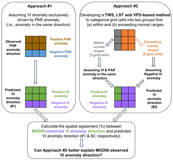
Greenness of the Amazon forest fluctuated during the 2015–2016 drought, but no satisfactory explanation has been found. Based on water storage, temperature, and atmospheric moisture demand, we developed a method to delineate the regions where forests were under stress. These drought-affected regions were mainly identified at the beginning and end of the drought, resulting in below-average greenness. For the months in between, without stress, greenness responded positively to intense sunlight.
P. Hübner, J. Hou, and D. Iwaszczuk
Int. Arch. Photogramm. Remote Sens. Spatial Inf. Sci., XLVIII-1-W2-2023, 1207–1214, https://doi.org/10.5194/isprs-archives-XLVIII-1-W2-2023-1207-2023, https://doi.org/10.5194/isprs-archives-XLVIII-1-W2-2023-1207-2023, 2023
M. Goebel and D. Iwaszczuk
ISPRS Ann. Photogramm. Remote Sens. Spatial Inf. Sci., X-1-W1-2023, 695–702, https://doi.org/10.5194/isprs-annals-X-1-W1-2023-695-2023, https://doi.org/10.5194/isprs-annals-X-1-W1-2023-695-2023, 2023
D. Stütz, J. Li, J. Huai, and D. Bulatov
ISPRS Ann. Photogramm. Remote Sens. Spatial Inf. Sci., X-1-W1-2023, 589–596, https://doi.org/10.5194/isprs-annals-X-1-W1-2023-589-2023, https://doi.org/10.5194/isprs-annals-X-1-W1-2023-589-2023, 2023
B. Kottler, S. Fischer, E. Strauss, D. Bulatov, and P. Helmholz
ISPRS Ann. Photogramm. Remote Sens. Spatial Inf. Sci., X-1-W1-2023, 271–278, https://doi.org/10.5194/isprs-annals-X-1-W1-2023-271-2023, https://doi.org/10.5194/isprs-annals-X-1-W1-2023-271-2023, 2023
D. Bulatov, M. Hecht, B. Kottler, J. Mispelhorn, and E. Strauss
ISPRS Ann. Photogramm. Remote Sens. Spatial Inf. Sci., X-1-W1-2023, 9–16, https://doi.org/10.5194/isprs-annals-X-1-W1-2023-9-2023, https://doi.org/10.5194/isprs-annals-X-1-W1-2023-9-2023, 2023
Martin Schwartz, Philippe Ciais, Aurélien De Truchis, Jérôme Chave, Catherine Ottlé, Cedric Vega, Jean-Pierre Wigneron, Manuel Nicolas, Sami Jouaber, Siyu Liu, Martin Brandt, and Ibrahim Fayad
Earth Syst. Sci. Data, 15, 4927–4945, https://doi.org/10.5194/essd-15-4927-2023, https://doi.org/10.5194/essd-15-4927-2023, 2023
Short summary
Short summary
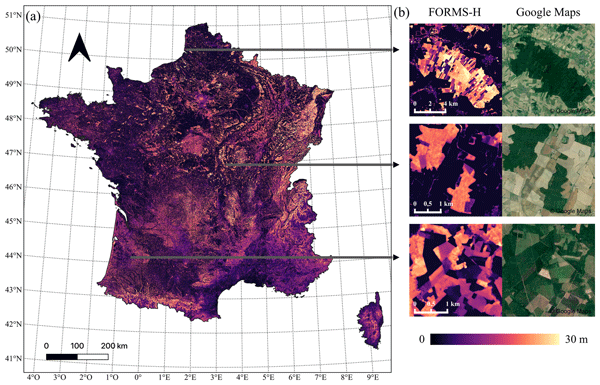
As forests play a key role in climate-related issues, their accurate monitoring is critical to reduce global carbon emissions effectively. Based on open-access remote-sensing sensors, and artificial intelligence methods, we created high-resolution tree height, wood volume, and biomass maps of metropolitan France that outperform previous products. This study, based on freely available data, provides essential information to support climate-efficient forest management policies at a low cost.
L. E. Budde, J. Schmidt, T. Kullmann, and D. Iwaszczuk
Int. Arch. Photogramm. Remote Sens. Spatial Inf. Sci., XLVIII-1-W3-2023, 25–30, https://doi.org/10.5194/isprs-archives-XLVIII-1-W3-2023-25-2023, https://doi.org/10.5194/isprs-archives-XLVIII-1-W3-2023-25-2023, 2023
L. E. Budde, T. Kullmann, and D. Iwaszczuk
Int. Arch. Photogramm. Remote Sens. Spatial Inf. Sci., XLVIII-1-W3-2023, 17–23, https://doi.org/10.5194/isprs-archives-XLVIII-1-W3-2023-17-2023, https://doi.org/10.5194/isprs-archives-XLVIII-1-W3-2023-17-2023, 2023
M. Goebel and D. Iwaszczuk
Int. Arch. Photogramm. Remote Sens. Spatial Inf. Sci., XLVIII-1-W3-2023, 63–69, https://doi.org/10.5194/isprs-archives-XLVIII-1-W3-2023-63-2023, https://doi.org/10.5194/isprs-archives-XLVIII-1-W3-2023-63-2023, 2023
J. Schmidt, V. Volland, P. Hübner, D. Iwaszczuk, and A. Eichhorn
Int. Arch. Photogramm. Remote Sens. Spatial Inf. Sci., XLVIII-1-W3-2023, 183–189, https://doi.org/10.5194/isprs-archives-XLVIII-1-W3-2023-183-2023, https://doi.org/10.5194/isprs-archives-XLVIII-1-W3-2023-183-2023, 2023
J. Schmidt, V. Volland, D. Iwaszczuk, and A. Eichhorn
Int. Arch. Photogramm. Remote Sens. Spatial Inf. Sci., XLVIII-1-W1-2023, 443–449, https://doi.org/10.5194/isprs-archives-XLVIII-1-W1-2023-443-2023, https://doi.org/10.5194/isprs-archives-XLVIII-1-W1-2023-443-2023, 2023
D. Iwaszczuk, M. Goebel, Y. Du, J. Schmidt, and M. Weinmann
Int. Arch. Photogramm. Remote Sens. Spatial Inf. Sci., XLVIII-1-W1-2023, 199–206, https://doi.org/10.5194/isprs-archives-XLVIII-1-W1-2023-199-2023, https://doi.org/10.5194/isprs-archives-XLVIII-1-W1-2023-199-2023, 2023
J. Hou, M. Goebel, P. Hübner, and D. Iwaszczuk
Int. Arch. Photogramm. Remote Sens. Spatial Inf. Sci., XLVIII-1-W1-2023, 183–190, https://doi.org/10.5194/isprs-archives-XLVIII-1-W1-2023-183-2023, https://doi.org/10.5194/isprs-archives-XLVIII-1-W1-2023-183-2023, 2023
E. Strauss and D. Bulatov
ISPRS Ann. Photogramm. Remote Sens. Spatial Inf. Sci., X-4-W2-2022, 265–272, https://doi.org/10.5194/isprs-annals-X-4-W2-2022-265-2022, https://doi.org/10.5194/isprs-annals-X-4-W2-2022-265-2022, 2022
D. Bulatov, B. Kottler, E. Strauss, G. Häufel, M. May, P. Helmholz, and F. Mancini
ISPRS Ann. Photogramm. Remote Sens. Spatial Inf. Sci., V-4-2022, 251–258, https://doi.org/10.5194/isprs-annals-V-4-2022-251-2022, https://doi.org/10.5194/isprs-annals-V-4-2022-251-2022, 2022
L. E. Budde, J. Schmidt, A. Javanmard-Ghareshiran, S. Hunger, and D. Iwaszczuk
ISPRS Ann. Photogramm. Remote Sens. Spatial Inf. Sci., V-1-2022, 187–193, https://doi.org/10.5194/isprs-annals-V-1-2022-187-2022, https://doi.org/10.5194/isprs-annals-V-1-2022-187-2022, 2022
M. Böge, D. Bulatov, D. Debroize, G. Häufel, and L. Lucks
ISPRS Ann. Photogramm. Remote Sens. Spatial Inf. Sci., V-3-2022, 179–186, https://doi.org/10.5194/isprs-annals-V-3-2022-179-2022, https://doi.org/10.5194/isprs-annals-V-3-2022-179-2022, 2022

The International Society for Photogrammetry and Remote Sensing is a non-governmental organization devoted to the development of international cooperation for the advancement of photogrammetry and remote sensing and their applications. The Society operates without any discrimination on grounds of race, religion, nationality, or political philosophy.
Useful Links
Useful External Links
Our Contact
c/o
Leibniz University Hannover
Institute of Photogrammetry and GeoInformation
Nienburger Str. 1
D-30167 Hannover
GERMANY
Email: isprs-sg@isprs.org